Monday, 22 March 2021

JATAR DEUL


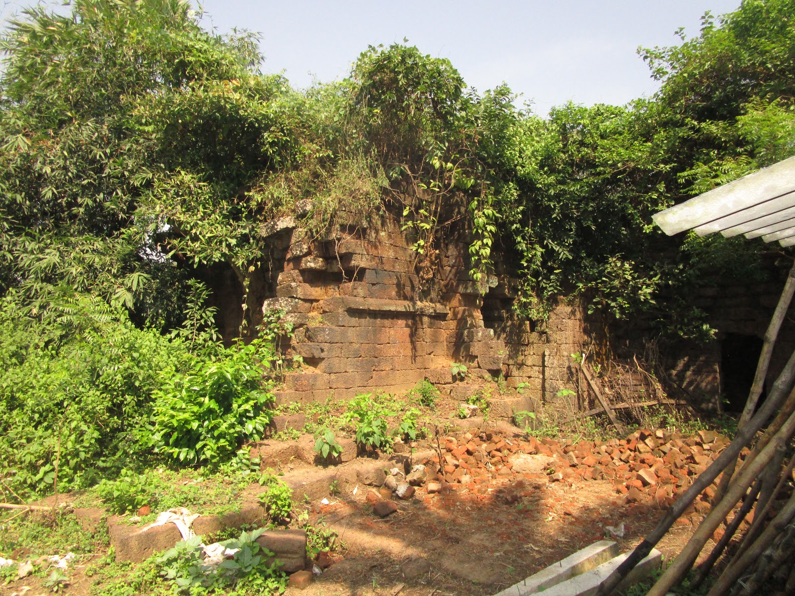
Jatar Deul, a Orissa Style masonry temple located at the gateway of famous Sundarban, Raidhigi under South 24 Parganas district of West Bengal is an ASI declared heritage structure. Today the temple is connected with nice bituminous road and within a decorated garden but a century back; the same place was infested with ferocious animals, reptiles and insects.


The South 24 Parganas is boasts of several archaeological remains that have been lying scattered in different places. Out of which Jatar Deul remained always been a place of interest for people studying ancient civilization. It is to be noted that Kankandighi and Jata at Raidighi police station in South 24 Parganas had been rich in archaeological remains. In the village of West Jata, there exists the ancient and lofty Jatar Deul temple.


During the river route survey of lower Ganga by English surveyor Renel (1764-77) first glimpsed this structure within a dense forest . During the colonial drive of deforestation and reclamation of Sundarban land and resident lease-holders, land–owners located the Jatar Deul in a deplorable condition. The 1868 Asiatic Society Journal (December) contained the first photograph of the structure snapped by Swainho- an Englishman, who also orated the structure to be of Buddhist origin.

The historical significance of Jatar deul was first highlighted by Mr. Kalidas Dutta in 1930. Kalidas Dutta’s intensive surveys highlighted a wealth of archaeological evidence in brick remains preserved in mounds; temple ruins stone and bronze images of Buddhist, Jain and Brahmanical deities. “Regarding its present name of Jatar deul two legends are prevailing ” as Mr. Kalidas Dutta writes “ …One is that this tract was frequented by a tiger which had a jata, or a clotted fur. The second one which is referred to in the List of Ancient Monuments in Presidency Divisionis that the tower held a Siva image known as ‘Jatadhari’ " Mr. Kalidas Dutta continues “ The only historical evidence that we know of is a copper –plate said to have been discovered at the site and referred to in the List of Ancient Monuments , Page-3 as follows – “The deputy collector of Diamond Harbour reported in 1875 that a copper plate discover in a place a little to the north of Jatar Deul fixes the date of the erection of this temple by Raja Jayanta Chandra Chandra in the year 897 of the Bengali Sak era corresponding to A. D.975. The copper plate was discovered at the clearing of the jungle by the grantee Durga Prasad Choudhury.”  The inscription is in Sanskrit and the date as usual was given in an enigma with the name of the founder. Unfortunately no trace is now available to this copper plate nor does the name of King Jayanta Chandra occur in any other known inscription or any other record.”


But modern research showed a continual presence of a dynasty - Chandra (Minor independent kingdoms during the Pala Period) who had ruled in south-eastern Bengal (Vanga & Samata) for about a century and a half from the beginning of 10th century AD. Discovery of quite a few copper plates of the rulers of this dynasty now affords the reconstruction of a connected history of this Dynasty and the history of the South Eastern part of Bengal is now clearer than 50/60 years ago, when only the name of one of its rulers (Srichandra) is known. The epigraphic records now provide clear evidence of a continuous rule of this dynesty for five generations in Vanga and Samatata when the Palas were ruling in Northern and Western part of Bengal and Bihar. The separate political entity of south eastern Part of Bengal under the the Chandras is now firmly established in the history of Ancient Bengal.

Lama Taranatha, The Tibetan Historian, gives prominence, in the history of Buddhism to a long line of kings ruling in Bengal, whose names end in –Chandra and who are specifically referred to as belonging to the Chandra Dynasty. In fact, this is the only dynasty in Bengal, before the Palas to which he has referred in his book. There is no room for doubt of human settlement in the Sundarbans in the early and in the medieval historic periods. It is now widely accepted among the Historians and Archaeologists. The region exhibits an evidence of early settlement in some of its parts. Several political upheavals coupled with natural calamities changed the direction of historical courses in many occasions.


The tower bears a striking resemblance to a similar tower on the South bank of the Ajay River near kenduli, which is known as Ichhai Ghosher Deul. This Ichhai Ghosh is said to have lived at the time of Devpala, the son and successor of king Dharmapala and the Jatar Deul may possibly be ascribed to that age. Earlier evidences show that the Pala rulers Gopala and Devapala conquered a vast portion of Lower Bengal including the territories of the districts under consideration. The Monghyr copper plate inscription of Devpala mentioned that Gopala conquered the earth as far as the sea. Another important territorial division of Ancient Bengal was Vyaghratatimandala. The Khalimpur and Nalanda copper plate inscription mentioned the region of Vyaghratatimandala under pala ruler. This Vyaghratatimandala has been identified as a part of costal Bengal including the present district of South 24
  Parganas (Ancient Samatata).


The district of South 24 Pargans as a centre of Buddhism first mentioned in Dakarnava Tantra where it mentioned a pithas like Radha, Dhikkari, Vanlara and Harikela. The Rakshaskhali copper plate inscription mentioned a Buddhist Vihara which situated outside of the village Vahamita (?) called Ratnatraya Mahavihara. The recent archaeological discoveries in lower West Bengal and Bangladesh are firmly indicating that once a rich Buddhist culture prevailed in this locality.

Sincere efforts on the part of the famed researcher and son of the soil Kalidas Dutta and extensive support of A.S.I have helped in renovating the Jater Deul soon after the deforestation of its adjacent areas. Though these efforts have helped in conservation of the temple, its artistic structures and constructional patterns have been largely affected. It however should be remembered that during the first decades of the previous century not much could be done for conservation of archaeological relics in a hostile land like the Sundarbans.

The tradition of local scholastic pursuit of Kalidas Dutta is well continued; another son of the soil Mr. Debishankar Middya establishes a relation between this monument and Ichai Ghosher Deul (Ichai Ghosh a character of Dharma Mangal Kavya) but, unlike Dutta situates it in the late eleventh/early twelfth century CE. He identifies an Iswar Ghosh mentioned in the Ramgunj copper-plate of the eleventh century CE with Ichai Ghosh. Iswar Ghosh is purporated to have established a second capital in Dhekkari. Mr. Mirdha argues for its location in lower Bengal and considers the confluence of Jatoda and Thakuran Rivers to the north of Jata to be the site of Dhekkari. The Deul, according to Mr. Middha , was constructed in the late eleventh century CE, dedicated to the god Sankara or Shiva. With the enthusiasm of local scholars ultimately ASI conducted archaeological exploration and partial parts of the other portions of the enclave came in the view.


Since Kalidas Datta’s writings in the 1930s, Jatar Deul has emerged as the pivot of cultural pride of local scholars who ascribe different religious affiliations to the tower, despite the fact that no image of worship was found at the time of its recovery in the late 19th century. A common perception is that the tower is in the form of a linga (phallus) and a garbhagriha sanctum housing the idol is in the form of a Yoni (Womb).These, together with lotus motifs present on the exterior wall, are interpreted as evidence of linga worship-an intrinsic part of Saivism-practice by those belonging to the trantric creed.

Linga worship in lower Bengal which saw its most classic manifestation in the Jatar Deul.
  Mr Sanjoy Ghosh’s (Local Scholar) writings draw rather unconventional practices of a local nathajogi community and the towers construction. The Nathajoc community, who have adopted the title of Debnath, practice Linga worship. Mr. Sanjoy Ghosh links linga worship with tantricism and argues that the duel in the shape of a linga was constructed by a community practicing Tantric Buddhism in Bengal in the eighth century. This community later transformed into the nath community. The prevalence of linga worship in the region is not doubted. However, its association with the Jatar Deul on the basis of its supposed architectural resemblance to the Linga, as Mr. Ghose argues, is not tenable.

The single commonality that emerges from these writings is the agreement that, architecturally, Jatar Deul belongs to the Orissan school of architecture. They reflect the voices local/grass-root scholars of the Sundarbans and south 24 parganas who consist of school Teachers, individuals working in the capacity of governmental employees, and self-employed individuals engaged in a passionate pursuit of past glories of the region.


As historian, Bishnupriya Basak well observes, “We see that since Mr. Kalidas Dutta’s initial scholarship, over the past several decades, a large collection of knowledge has grown among these individuals who are neither residents of the village, nor professing any religious affiliation to the either Shaiva, Tantrik, Buddhist or Jain religions. They claim that they make to lay stake to Jatar Deul stem from intellectual deliberations only.”


Setting aside all this institutional scientific exploration and individual scholastic approach Jatar Deul stood mesmerized its viewers and it stood as it is since 11th Century (as per erected ASI Board). Even if your interest is not exploration of ancient heritage or study of masonry structure you can very well feel the impact of this brick made cylindrical structure.

It emblems- a large number of Bengal aboriginal inhabitants at the gateway of modern mangrove patch of Indian Sundarban, an advance society so far construction technology, commercial resources were concerned, probably a shore-temple within a populace harbour- thriving with sea-trade - then, probably an unprecedented natural calamity, change in land mass and water ways, civilization erased out, mangrove extends its area, oblivion of an original heritage.

Several centuries passed by, the river routing survey of the colonial ruler re-explored it, afterwards the reclamation drive of forest land lead to its re-emergence; today it is an ISI protected heritage structure in independent India.

Jatar Deul clearly throws the challenge to its viewers- are you truly aware of the history of your country?


 Research: Santanu Roy and Abhijyan Basu.

 Photography : Tathagata Sen & Santanu Roy

 Sources :

         1.    Antiquities of Khari, Varendra Research Society's Monograph No.3 Rajsahi, Varendra                             Research Sociity, by Kalidas Dutta.

         2.    The History of Bengal By Ramesh Chandra Majumder. Dhaka.

3.    Dynestic History of Bengal by Abdul Momin Chowdhury.

              Chandra Dynasty by A.M. Choudhury. Asiatic Society of Bangladesh.

4.    Pierre-Yves Manguin ;  A Mani ; Geoff Wade (2011) . Early Interactions between South East Asia : Reflections of cross cultural exchange. Institute of South Asian Studies.                     

5.    Nagendra Kr. Singh . Encyclopedia of Bangladesh.

6.    The journey of Kalidas Dutta and the construction of Regional history in pre and post independent Bengal, India. By Bishnupriya Basak.

7.    The dynamics of heritage- making at an archaeological site in South 24
Parganas, Bengal, India. By Bishnupriya Basak.

8.     Ancient History of Bengal : http://dspace.wbpublibnet.gov.in:8080/jspui/ http://dspace.wbpublibnet.gov.in:8080/jspui/bitstream/10689/13287/10/Chapter%20VI-VII_199-237p.pdf

9.    Jatar Deul : Sanskritik Nritattva-er-drishtikon theke ( Jatar Deul : From the Perspective of cultural anthropology) Vivekbarta.

10.  Jatar Deul-er –Itibrittya (Chronicles of Jatar Deul) by Debisankar Middha, Raidighi :Jatar Deul Sanskriti Sangha.

11.  Dakshin Chabbish Parganar Bisrto Adhya and Dakshin Chabbish Parganar  Purakatha by Krishnakali Mondol.https://archive.org/details/in.ernet.dli.2015.265432 

12. Sundarboner Moni Abobahika by Nirmalendu Mukhopadhya

13.  Jatar Deul ek Ananya Sthapatya Kirti By Dilip Ghosh.Suchetana.

14.  Journal of ancient Indian History, Some epighaphical Records of the Mediaeval period from Eastern India, Journal of Ancient Indian History and       Epighaphical discoveries in East Pakisthan By Dinesh Ch. Sarkar.

15.  New Light on the History of Ancient South-East Bengal, by Shariful Islam    Asiatic Society of Bangladesh, Dakha

16. Sundarbaner Saktipith : Chatrobhog By Debishankar Middya.

17. The Temple of Pashim Jata (South 24 parganas, West Bengal.) Sarmila Saha ,Dipartment

       of Historty, Calcutta girls College (Pratna Samisha,2011,ASI)Pratna Samiksha 11 Sharmila Saha.pdf 


Tuesday, 30 July 2019

ABORIGINALS' FORT OF PALAMAU


Palamu is one of the twenty four districts of the Eastern Indian state Jharkhand. From time immortal, Palamau portrays waves of unending small hillocks, dense forest and rain feed seasonal rivers. Its natural beauty, unpolluted air, forest resources and simple lifestyle of forest tribes attracted Indian writers, film makers and tourists for centuries. Through it is not too far from the East Indian urban centre it successfully retained its rustic virgin beauty.


It is situated at Auranga river about 20 miles south-east of Daltenganj (nowadays Medininagar). It is beyond southern limits of Bihar: spread over an uneven land, leading to the plateau of Chotonagpur( geologically one of the earliest land mass of our planet) in the south-east and the central provinces in the south west. In recent past the area faced severe maoist dominance. At present, not only the law and order situation becomes better; the entire district is equipped with new infrastructures.


The greatest tourist attraction of the area is the first Indian tiger reserve at Betla.  At stone throwing distance to the main entrance of the tiger reserve there remain two relics of fort. The official website of Palamu opens with the image of one of these structures but we have not found any board(s) of Archaeological Survey of India around those relics.


Autonomous tribes probably inhabited the area in past. Kharwars, the Oraons and the Cheros practically ruled over the tract. Palamau, according to Mughal historians (Fifteenth Century), lay south of Patna, the distance from latter to the northern boundary of the former being 71 miles. It is likely that the Cheros territory extended upto Daudnagar or Arwal, where the remains of the Cheros forts have been found. Toward the north-east, the Cheros were mentioned by Abul Fazal as the principal Zamindars in Chai Champa (Ramgharh) and Pundag (Palamau). Very little is known about the Kharwar rulers of Palamau. Haraprasad Shastri in his quest for origin of Buddhhsim in Eastern  India also came to this conclusion that the ethnic races ruled in the Chtonagpur  zone were Cher – an offshoot of Dravidian aboriginals. 


Prior to the domination of Palamau by the Cheros, Rakshel Rajputs held sway over the district. They have probably been assimilated in the indigenous population. The Rakshels had reached Palamau by moving through Rohtasgarh from the Rajputana area of Rajasthan. Later on they were thrown out by the Cheros. The area was probably inhabited by indigenous tribes in the past. Besides the Kharwars, Oraons and Cheros.  other tribes related with Palamau were the Gonds, the Korwas, the Paharis and the Kisans.The Kharwars outnumbered other tribes.


In order to understand the real cause of many of the village disorders in Mughal times, we must bear in mind that the population was dynamic, not static. Internal movements of the people were constantly going on. In different generations different tribes migrated to new districts and tried to push away the older settlers in order to make home for themselves. A clan that had entered a district as servants and tenants, in a few generations grew strong enough to overthrow their masters and became the dominant race and owner of the land.


Three aboriginal races practically ruled over this tract. Inscriptions and other relics which have been found indicate a fairly developed civilization in spite of the jungles and comparative inaccessibility of the area. The Oraons had their head quarters at Rohtasgarh in the then Sahabad district. And there is every indication that for some time a portion of Palamau was ruled from the head quarters of Rohtasgarh. The Cheros reigned in Palamau for nearly 200 years and the most famous of Chero rulers was Medini Rai who according to tradition made himself lord paramount of the  southern portions of Hazaribag and Sarguja ( in Madhya Pradesh). 


Historians and local people of Palamau differ on the date the fort was built. However the conscious view is that the old fort was built by the Rakshels before the Chero dynasty. Raja Medini Rai, a tribal Chero king who ruled between 1662-1675, rebuilt the old fort, making it into a sprawling, impregnable and majestic structure overlooking the meandering Oranga river, surrounded by densely wooded hillocks. Raja Medini Rai was capable, upright and benevolent king known for his in-depth knowledge of warfare as well as his astute leadership.


As per the details kept in the local Government Museum, the fort belonged to the adivashi Chero King. Cheros fought gallantly against Mughal invasion from Akbar’s period. Ultimately in second half of seventeenth century Cheros were defeated by the Mughal army. The relic clearly indicates its Islamic face-lifting. As per Alamgirnama Mughal General Daud Khan demanded Cheros their tribute to Delhi and complete conversion of the Hindus to Islam. Cheros fiercely fought for their liberty and honour but were defeated.  Even Daud was very slow in his progress with his army, as the area was a dense forest. He had to move by constructing road for his army ; hence his marching in Palamau was in snail’s pace(1660-1661).


The mammoth size of both the relics clearly indicate that once upon a time a huge urban and military population was there within a dense forest. Chero King Medini Rai or his linage might have accumulated tremendous resources but how did they erect such structures within the dense forest? That means Cheros inherited the basic structures and then renovated as per their own requirement. Chero kings are termed as Vanvashi kings. It is clearly indicated that during Chero’s regime the fortification was within the forest.


It is clear that during a glorious past a huge human civilization with urban influence might have flourished in and around today’s Betla, might be the place was urbanized not like the deep forest which is recorded since 1660. Interestingly, the locals available as drivers of jeeps, guides of the jungle trail and mahout of the elephant safari at the main gate of the Betla National Park are practicing Muslims- that might be the signature of Daud Khan’s invasion.


As often happens in the annals of history when an able ruler passes away, the entire dynasty fall apart as was evident following Raja Madini Rai’s death due to power struggles and in-fighting in the ruling family. The administration slowly and indirectly passes into the hands of various ministers and advisors who are driven by personal gain rather than dynasty. It is difficult to ascertain who the real betrayers were but the dynasty struggled with controversies and lacked any real achievement, starting from the reign of Raja Pratap Rai to that of Raja Rudra Rai, Raja Dikpal Rai, Sahab Rai, Joy Kishan Rai, and finally Chiranjit Rai.


We came across certain pre-independence records of both forts under British Administration in Imperial Gazetteer of India and annual report of Archaeological Survey of India- mentioning some fund requirement of proposed renovation. The history of the Forts under British Raj had a very common pattern – Hindu native landlords of Palamau under British protection, inheritance disputes, placement of more puppet Hindu landlords, aboriginal rebellion, failure of paying revenue to the administration, and ultimately the entire Palamau forest and the decadent forts went under the sole British control. (By the middle of July 1771, the East India Company established its authority over the whole Palamau).  During our research we came to know of one thesis paper of Tahir Hussain Ansari, where in 2008, he was referring to one portrait in connection with the Mughal invasion of Palamau Fort (he mentioned that the masterpiece was in Mannulal Librbrary, Gaya). In relation to this portrait, Ansari took the words of W.W.Hunter for describing the foot solders  “…..majority are black, with loin cloth, and bare heads and bare feet, bows with one curve and plenty of arrows, besides which some have  spears, some swords and some shields.” Does it not represent Indian independence ? The 1857 Sepoy Mutiny is now embalmed as the first struggle for Indian Independence – why are we forgetting about the Cheros ? is not this portrait important to the modern day Indians ? Is not this portrait a piece for national archive ?


It is clear that the property (fort) was in its deploring condition during British Raj but unfortunately it remained in the worst state today. It appears that from 1660 onwards the structures are standing within the forest without slightest of maintenance. Now in our country a drive is carried out for revisiting our glorious past for rewriting a truthful history of our country. Is anyone working on those forts?


The aboriginals of Palamau were known for their fierce sense of liberty- it was amply recorded during entire British Raj time and again. Might be the same spirit somehow went in these structures; human civilization and administration of the country have forgotten about them but somehow they kept themselves stood tall within a dense forest and challenging nature against their intended oblivion .


Research:  Santanu Roy and Abhijyan Basu.

Photography:  Debabrata Roy.


Sources :
1. Ain-I -Akbari by Abul Fazal . Ed. Saiyed Ahmad Khan. 1986.(pdf file)
2. The comprehensive history of Bihar, The Cheros by K.S. Singh ed. Sayd Hasan Askari
    and Q. Ahmad.
3. Bahiristan-I -Ghalybi By Mirza Nathan, Vol-1. Tr. by B.I. Borah. Guwahati 1936.
4. The Statistical Account of Bengal by William Wilson Hunter.
5. A historical account of Chotanagpur. Journal of Historical Research, 1960. Voll-3
    Ranchi University.
6.  Dynamics of Tribal migration of India by Ranjit Toppo. Xavier Institute of social 
     Service (Ranchi, India)
7.  History of Aurangzeb (Northern India, 1658-1681) by Acharya Jadunath Sarkar.
     2nd. Edition. Published by S.C.Sarkar (pdf).
8.  India : An illustrated Tribal World by Hrisikesh Mondal, Sumit Mukherjee & Archana
     Dutta. Anthropological Survey of India.
9.  Haraprasad Shastri Rachanaboli- Part-3, Article "Bouddha Dharma Kothay Gelo" 
     Publishing Year 1917.
10. "The Cheros of Palamau" by Tahir Hussain Ansari.  An article published in Sodhganga.
11. Lastly, Mr.  Debabrata Roy. a wildlife enthusiast, without his cordial help and co-                    operation , we could not proceed to document this remarkable fort.

Saturday, 23 March 2019

JINSAR ( JIN SAHAR) - ANCIENT RUIN OF A TEMPLE


If anybody searches in google map “JINSAR , WEST BENGAL”, a location in west Medinipur will  appear  on the screen along with blue marking of Kanshabati river.  With a little zoom-in will show a label “Ancient Ruin of a Digambar Jain Temple” more towards the river. Recently two bloggers had shared their findings on this ruin through their article; one of them a historian and the other an enthusiastic travelogue writer. Based on one of their reports, another  information is also evident in face-book.


Way back in fifties when the eminent Bengali scholar Binay Ghosh visited Medinipur to collect materials for his monumental book “Paschimbanger Sanskriti” (The culture of West Bengal). During this travel he had been to this place and pointed out that “Jinsar” denotes Jin Sahar (City of Jain). 


If one observes the current maps of Jharkhand and West Bengal one finds distinct links of age old Jain heritage at different locations of lower eastern part of Jharkhand and lower western part of West Bengal (Giridih- Dhanbad- Bokaro- Puruliya- Bankura- West Midinipur). These links are broadly classified in two groups. The first one, earlier Jain structures still in use as hindu temple (Begunia in Barakar, West Bengal) or Jain statue becoming symbol of hindu God (dressed in red loin-cloth) placed inside a new structure attracting regular attention of devotees (Polkiri in Bokaro, Jharkhand). The second group is the heritage structure which were submerged during the construction phase of reservoirs of DVC Project (Telkupi ,Puruliya, West Bengal) in early fifties. A few, however, became visible since 2005 due to silting .


One observes that all these Jain Temple clusters were developed beside river networks of Damador, Barakar and Kanshabati, clearly indicating a primary navigational river high-way for commerce of an age old civilization. Budhist and Jain Sreshthis (merchants) were common characters in old scriptures as well as in modern texts of nineteenth century. The construction material is not burnt-brick but finely cut stone brought from outside Bengal, suggesting patrons had rich resources. The period of execution accessed eleventh to twelfth century.


As per Jain documentation the aboriginals of this place (Porto- Australoid Tribes) were not having any friendly attitude towards Thirthankar Mahavir. Was it an indication of conflict between rude Foragers and cultured Aryans ?


Available archeological evidences of Tamluk (Tamralipto) region of southern Medinipur strongly indicate it as a seat of non-Aryan civilization of copper-age transformed into a busy river harbor and into a Buddhist university-town (?) between fourth and seventh century (documented travelogue of famed Chinese Monks). In eleventh century it became A part of the Kingdom of Rajendracholdev and in twelfth century it came under the administration of Chorgangadev. The Buddhist and Jain doctrines of different eras were having their simultaneous influence in Medinipur. The eco-political scenario of this particular landmass of modern West Bengal withstands the cultural syntheses of south as well as north India. Whatever might be the historic socio-religious evolution of this area the western part of this district always displayed the urge for independence and determination to avail the same (Forager’s gene? / Red Corridor ?). It had survived as the battlefield between Mughal and Pathan; it remained the soft-target of yearly Maratha invasion of Bengal during the fag end of Mughal Dynasty; the “Chuar Rebellion” was the first revolt against administration of British India much before “Sepoy Mutiny” of 1857 (unfortunately never highlighted beyond scholastic world).


The ruin of “Jinsar” is remarkable as this age old piece of heritage structure is going towards oblivion due to extreme negligence from modern India. The district which withstood wave after wave of military onslaught, religious vortex and political turmoil failed to preserve its archeological beauty. On the other hand, extensive touring in this region (eastern part of Jharkhand and lower western part of West Bengal) gives the impression: “against the huge time scale the religion of the locality changed from one form to another but the God’s Idol remains live by the believers. It had remained a solace to the villagers; it would continue its peaceful influence on the anxious minds in future. Religion, society and time may change but the Idol remains as an assimilation of Indian heritage and legacy forever, and continued to be an emblem for all hopes and good deeds and a symbol of destroyer of all evils”.
The old Jain statue of ruined Digambar Jain Temple of Jinsar proved the above theory absolutely wrong.


If you feel anyway curious about this relic please go through the below mentioned links, as modern Indian it is our duty to preserve our heritage.


Sources :


4. Pashimbanger Sanskriti by Binoy Ghosh
5. Special courtsey  Mr. Tarun Tapas Mukherjee & Md. Yeasin Pathan.

Research : Abhijan Basu and Santanu Roy.
Photo courtsey : Santanu Roy.